Environment and society
Transformation of the countryside
![]()
Dissection of the countryside 1935–2002: average size of a non-dissected area in km2
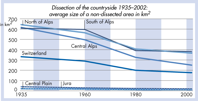
Definitions/Comments: territories below 2100m. The geometry of dissection is based on the criteria of possible settlement, i.e. areas such as glaciers and lakes have been excluded. The following are considered as barriers or elements of dissection: motorways, roads (classes 1–3), tracks, settlements, rivers, lakes and mountains (territories above 2100m).
Source: Jaeger, Jochen; Rene Bertiller and Christian Schwick (2007), Landschaftszerschneidung Schweiz: Zerschneidungsanalyse 1900 bis 2002 und Folgerungen für die Verkehrs- und Raumplanung. Neuchâtel: SFSO, Federal Roads Office (FEDRO), FOEN, Federal Office for Spatial Development (ARE).
Data for the indicator or in excel.
Description and explanation in the corresponding chapter of the Social Report 2008.